
WATERWAYs
Waterways are vital transportation routes for goods and passengers, offering a cost-effective and environmentally friendly alternative to road and rail transport. They play a central role in the economy by facilitating trade and connecting inland regions to seaports.
The functionality of waterways depends on several factors, including sufficient water depth and width to ensure navigability, as well as regular maintenance to prevent obstacles such as sediment deposits. Operational hydraulic structures, such as groynes, locks, and other infrastructure components, are also crucial for enabling smooth and safe transport while ensuring flood protection for adjacent settlements.
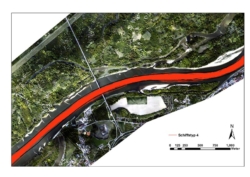
Technical measures to optimize navigation conditions, particularly during low water levels in the fairway, primarily include guiding structures and groynes. Guiding structures direct the flow in the desired direction, while groynes concentrate the flow toward the center of the river, thereby increasing water levels.
Digital Waterways
The positions of all ships on the Danube are continuously recorded through the DoRIS (Danube River Information Services) system and displayed on an electronic inland navigation chart, the Inland-ECDIS. This is achieved through the targeted use of satellite positioning, data radio, and advanced visualization technology. The analysis of the data generated by this system helps determine whether the marked navigation route is being followed or if adjustments to its course are necessary. This enhances traffic safety on the Danube.
Waterway Monitoring
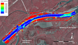
Monitoring waterways is essential to ensure the safety and efficiency of navigation. Continuous monitoring of fairway depths is required to maintain a minimum navigable depth and prevent ships from running aground. The morphology of waterways, including the shape and structure of the riverbed, must also be regularly examined, as changes caused by erosion or sedimentation can significantly impact navigability.
The wave action generated by passing ships can damage riverbanks and structures, making it necessary to closely monitor and, if needed, regulate its effects. Numerical models play a key role in this process, as they simulate complex hydrodynamic processes and provide predictions about future changes.
Hydraulic Engineering for Optimizing Navigation Conditions
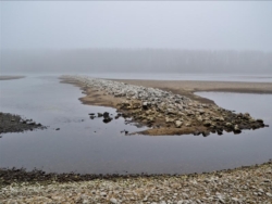
Traditionally, groynes have been constructed with an inclining or orthogonal, straight design to direct the flow away from the riverbank. However, in recent years, declining or curved groynes have been increasingly used to allow controlled erosion along riverbanks. This approach helps balance sediment deficits in the river while improving ecological conditions in the bank areas.
The design of hydraulic structures has a significant impact on flow dynamics and sediment transport in rivers. Careful planning and optimization are therefore necessary to achieve both ecological and engineering objectives.
Flexible Infrastructure in Waterways
Historically, a form of flexible infrastructure was already in use in Vienna at the Nussdorf site at the beginning of the 20th century. During high water levels, a floating gate was placed across the entrance to the Danube Canal to prevent drift ice from entering the city. This concept is being revisited today in modern hydraulic engineering, where interventions are designed to be as minimal as possible while still fulfilling their purpose. This approach is particularly relevant given the sediment imbalances observed in many rivers.
Modern sediment management serves both flood protection and the improvement of navigation and ecology. However, it also requires costly maintenance and hydraulic engineering measures. A common measure to ensure the necessary fairway depths in waterways is low-water regulation using groynes. These structures concentrate the flow in the main channel during low discharge conditions. However, at higher discharge levels, they can have counterproductive effects. Additionally, the areas along the waterway that require infrastructural measures, such as landing zones, can vary.
Viadonau, the Austrian waterway management authority, is working to integrate flexible infrastructure elements into its modern waterway management strategies. IWA supports these efforts through accompanying research, including on-site monitoring to observe direct effects, as well as the development of numerical and physical models to enable scenario planning and design optimization.