NUMERICAL MODELING
Numerical modeling at IWA is tasked with the computer-based simulation of processes in water bodies. This includes the investigation of flow dynamics, sediment transport, morphodynamics, and ecological habitats using computational models.
These models are used, among other purposes, to conduct parameter studies that analyze the impacts of interventions in water bodies. This enables the optimization of planned hydraulic engineering measures in the respective study area to achieve the desired effects as efficiently as possible while minimizing negative impacts.
In addition, spatially and temporally high-resolution models are applied in fundamental research. Hybrid modeling combines the advantages of physical and numerical models. The necessary data foundation for the calibration and validation of the models -i.e., their adaptation to natural conditions and verification using field data – is obtained through field monitoring.
At IWA, numerical models are not only applied but also developed from scratch to create innovative solutions for current and future challenges in water management.
Hydrodynamics
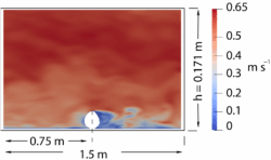
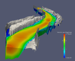
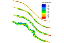
Hydrodynamics focuses on determining the spatially distributed variables of water depth (as a scalar) and flow velocity (as a vector quantity) for a given water body section. Higher-dimensional models additionally calculate various turbulence parameters. The models used range from simple 1D flow models for long river sections or extended time periods, to 2D models focusing on river sections of approximately 20–50 km in length, and even 3D models, which we have successfully applied to river sections up to 20 km in length.
At IWA, various software solutions are employed. 1D models are primarily created using the HEC-RAS software, 2D models with Hydro-AS or our in-house development RSim-2D, and 3D models mainly with our self-developed software RSim-3D. This wide range of modeling capabilities allows us to analyze hydrodynamic processes with precision and to develop tailored solutions for diverse challenges.
Sediment Transport and Morphodynamics
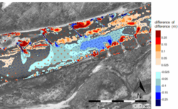
The modeling of sediment transport encompasses the processes of bedload transport, suspended load transport, bed evolution, and grain sorting. As a result, individual sediment transport mechanisms in a water body can be analyzed independently, or the morphodynamics of the riverbed resulting from all processes can be studied over short, medium, or long time periods. Similar to hydrodynamics, different model dimensions are used depending on the specific research question.
Most sediment transport modeling at IWA is conducted using our in-house development, iSed, which can be coupled with various 2D and 3D hydrodynamic models, including Hydro-AS, RSim-2D, and RSim-3D. This flexibility allows for the precise simulation of complex sediment transport processes and provides valuable insights for the planning and optimization of hydraulic engineering measures.
Habitat Modeling
The purpose of habitat modeling is to evaluate ecological habitats in water bodies for various species or guilds on micro- and meso-scale levels, based on the results of 2D and 3D hydrodynamic models. This evaluation can be conducted either for a steady or unsteady state (e.g., during the progression of a flood wave).
To this end, the Habitat Evaluation Model (HEM) was developed at IWA. Recent extensions, such as HEM-PEAK and HEM-Impoundment, now also enable the assessment of hydropeaking processes and impounded areas in water bodies.
High-Resolution Models
In 3D models used for engineering applications, the RANS turbulence approach (Reynolds-averaged Navier-Stokes) is typically employed. This approach averages the hydrodynamic conservation equations (Navier-Stokes equations) over turbulence scales. Additionally, there are methods for more precise and high-resolution turbulence calculations, such as Large-Eddy Simulation (LES) and Direct Numerical Simulation (DNS). Both methods resolve the computational domain with very high spatial and temporal resolution, making them computationally intensive and thus primarily used in fundamental research.
At IWA, the Open-Source model OpenFOAM and the Virtual Flow Simulator (VFS) developed by Stony Brook University are utilized for such applications.